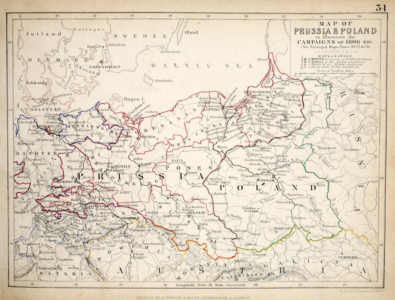
Map of Prussia and Poland, published by William Blackwood and Sons, Edinburgh and London, 1848 by Alexander Keith Johnston

Map of Prussia and Poland, published by William Blackwood and Sons, Edinburgh and London, 1848

(Map of Prussia and Poland, published by William Blackwood and Sons, Edinburgh und London, 1848 (hand-coloured engraving))


Alexander Keith Johnston

€ 0.00
Enthält ??% MwSt.
   Add to cart
   Configure art print
1848  ·  hand-coloured engraving  ·  Picture ID: 186706

Nonclassified artists  ·  Cartography

Map of Prussia and Poland, published by William Blackwood and Sons, Edinburgh and London, 1848 by Alexander Keith Johnston. Available as an art print on canvas, photo paper, watercolor board, uncoated paper or Japanese paper.
Private Collection / Bridgeman Images
zu Favoriten hinzufügen   Add to favorites    Select wall color    View painting in a room AR/3D   View in 3D / AR
0 Reviews

Configure art print

Picture Frame

Medium & Stretcher

Glass & Passepartout

Miscellaneous & Extras

 Save / compare configuration
Preview Icon

Summary

Gemälde
Veredelung
Keilrahmen
Museumslizenz

€ 116.48
(inkl. 20% MwSt)
   Add to cart

Bildschärfe: PERFEKT

Should you desire adjustments to brightness and color, or a custom crop of the motif, we are happy to make these changes at no additional cost to you. Please do not hesitate to contact us.

Similar artworks selected for you

General Map of European Russia and the Caucasian Countries Map of France on the death of Louis XIV in 1715 - engraving in Map of Germany, Germania Antiqua, from Map of France at the times of King Charles VII and after the expulsion of the English between 1422 and 1461 (Plate from Houze The Third Partition of Poland Map of the German Empire Map of France, c.1900 Map of Belgium Map of Russia and Poland Map of Russia and Poland Map of Muscovy Turkey in Asia Map of the Prussian States in 1799 Russia, from Europe, Describing All the Changes of Territory, Published 1816 Map of the Vyatka Governorate, c1914 Map of the Provinces of the Lower Ganges A New Geographical Pastime Exhibiting a Complete Tour Through France Respectfully Dedicated with Permission to the Right Honorable Lady Georgiana Cavendish Old Germania - Plate extracted from Map of Russia, 1902 Map of Armenia, Colchis, Iberia and Albania, from General Map of Nizhny Novgorod Governorate, 1788 General Map of Nizhny Novgorod Governorate Map of Spain and Portugal Map of French territories under tax, 1709 (from Le Theatre du Monde by Jean-Baptiste Nolin, 1717) Ferro. Unbound. Similar Version Described In South-East Czech Republic, West Slovakia, West Hungary, East Austria Map of Austria-Hungary Map of China and Burma, 1851 Map of the Vendee Depicting the Area of the Vendean Revolt (1793-96) in March 1793
Show more similar artworks

Other art prints by Alexander Keith Johnston

Map of the Battle of Trafalgar, published by William Blackwood and Sons, Edinburgh and London Map of Paris at the Outbreak of the French Revolution, published by William Blackwood and Sons Map of the Battle of Trafalgar, published by William Blackwood and Sons, Edinburgh and London, 1848 Map of the Battle of the Nile, published by William Blackwood and Sons, Edinburgh and London, 1848 Map of the Battle of Jena, published by William Blackwood and Sons, Edinburgh and London, 1848 Plan of the Battle of Cape St. Vincent, 14th February 1797, c.1830s Map of the Battle of Copenhagen, published by William Blackwood and Sons, Edinburgh and London, 1848 Map of the Battle of Hanau, published by William Blackwood and Sons, Edinburgh and London, 1848 Map of the Battle of Hohenlinden, Published by William Blackwood and Sons, Edinburgh and London Map of the Battle of Borodino, Published by William Blackwood and Sons, Edinburgh and London, 1848 A map of Spain and Portugal, c.1869 Map of the Battle of Rivoli, published by William Blackwood and Sons, Edinburgh and London Map of Prussia and Poland, published by William Blackwood and Sons, Edinburgh and London, 1848 Map of the Battle of Craone Map of the Battle of Hohenlinden, published by William Blackwood and Sons, Edinburgh and London, 1848
Discover more works by Alexander Keith Johnston

Other motives from the category Cartography

Map of the Siege of Malta in 1565 Map of Constantinople and Surrounding Areas, 1855-63 Plan of Paris, under the Reign of Henry II by Olivier Truschet and Germain Hoyau Map of the Magellan Straits, from Map of European Russia showing its Earliest Extent, its Encroachments upon Adjacent Countries, and the Present Boundary of the Empire Map of Australia, from Map of Persia, Arabia and India, from an atlas, 1571 Map showing the localities of the Indian tribes of the US in 1833, illustration from This Map of the City of New York and Island of Manhattan as Laid Out by the Commissioners Appointed by the Legislature, 1853 Detailed map of Gallipoli Peninsula and the Dardanelles Turkey, from Map of Ancient Egypt Map of Tunis, from Map of Venice, from Map of the World, Based on Descriptions and Coordinates Given in Map of the Countries of the Persian Gulf, from the
View More from "Cartography"

Excerpt from our top sellers

Pandora Playing Forms Waterlilies Self-Portrait (Melancholy of the Mountains). 1929 The Lonely Tree Portrait of the philosopher and esotericist Rudolf Steiner Reclining Semi-Nude (Masturbating) Landscapes, Flowers and Birds: Plum, Qing Dynasty The Wild Hunt of Odin The Last Supper The Palace of the Queen of the Night, Set Design for The Disciples Peter and John Running to the Sepulchre on the Morning of the Resurrection Cubist Lilies Karelia and Murmansk agitation panel, 1926 The Cactus Friend
Show More Artworks


What our customers think about us


Frequently Asked Questions about Meisterdrucke


Personalizing your art print at Meisterdrucke is a simple and intuitive process that allows you to design an artwork exactly to your specifications: Choose a frame, determine the image size, decide on a printing medium, and add suitable glazing or a stretcher frame. We also offer customization options such as mats, fillets, and spacers. Our customer service is available to help you design your perfect artwork.

At Meisterdrucke, you have the fascinating option to visualize the artwork you configured directly in your own space. For a tailored preview, simply upload a photo of your room and let the artwork appear on it. If you visit us via a mobile device, be it a phone or tablet, our augmented reality feature brings the image to life and seamlessly projects it into your space. An experience that uniquely combines art and technology.

Choosing the medium is often a matter of personal taste. To give you a clearer idea, we have provided some images for each medium. For a holistic experience, we also offer you a sample set of all paper variants so you can make a decision not just visually but also haptically. You can take advantage of the sample set free of charge – only the shipping costs will apply. You can order the sample set directly.

Do not worry. At Meisterdrucke, we do not proceed mechanically. We manually review each order. If there are any inconsistencies or peculiarities in the configuration, we will immediately contact you. Of course, our courteous and patient support is always at your side to assist you with the configuration. Together with you, we adjust your image by phone or email so that the final result exactly meets your expectations.


Do you have any questions?

Are you interested in an art print from our manufactory but still unsure? Do you need advice on choosing the medium or help with the order?

Our experts are happy to assist you.

+43 4257 29415
support@meisterdrucke.com
Mo-Do: 7:00 - 16:00 | Fr: 7:00 - 13:00

Do you have any questions?

Are you interested in an art print from our manufactory but still unsure? Do you need advice on choosing the medium or help with the order?

Our experts are happy to assist you.

+43 4257 29415
support@meisterdrucke.com
Mo-Do: 7:00 - 16:00 | Fr: 7:00 - 13:00


Meisterdrucke

   Kärntner Strasse 46
        9586 Finkenstein am Faaker See
        Austria
        +43 4257 29415
        support@meisterdrucke.com
Other languages

                   
Erfahrungen & Bewertungen zu Meisterdrucke
Partner Logos

Kaiser Franz Joseph

Meisterdrucke
Kärntner Strasse 46
9586 Finkenstein am Faaker See · Austria
+43 4257 29415 · office@meisterdrucke.com
Partner Logos


(c) 2025 meisterdrucke.uk