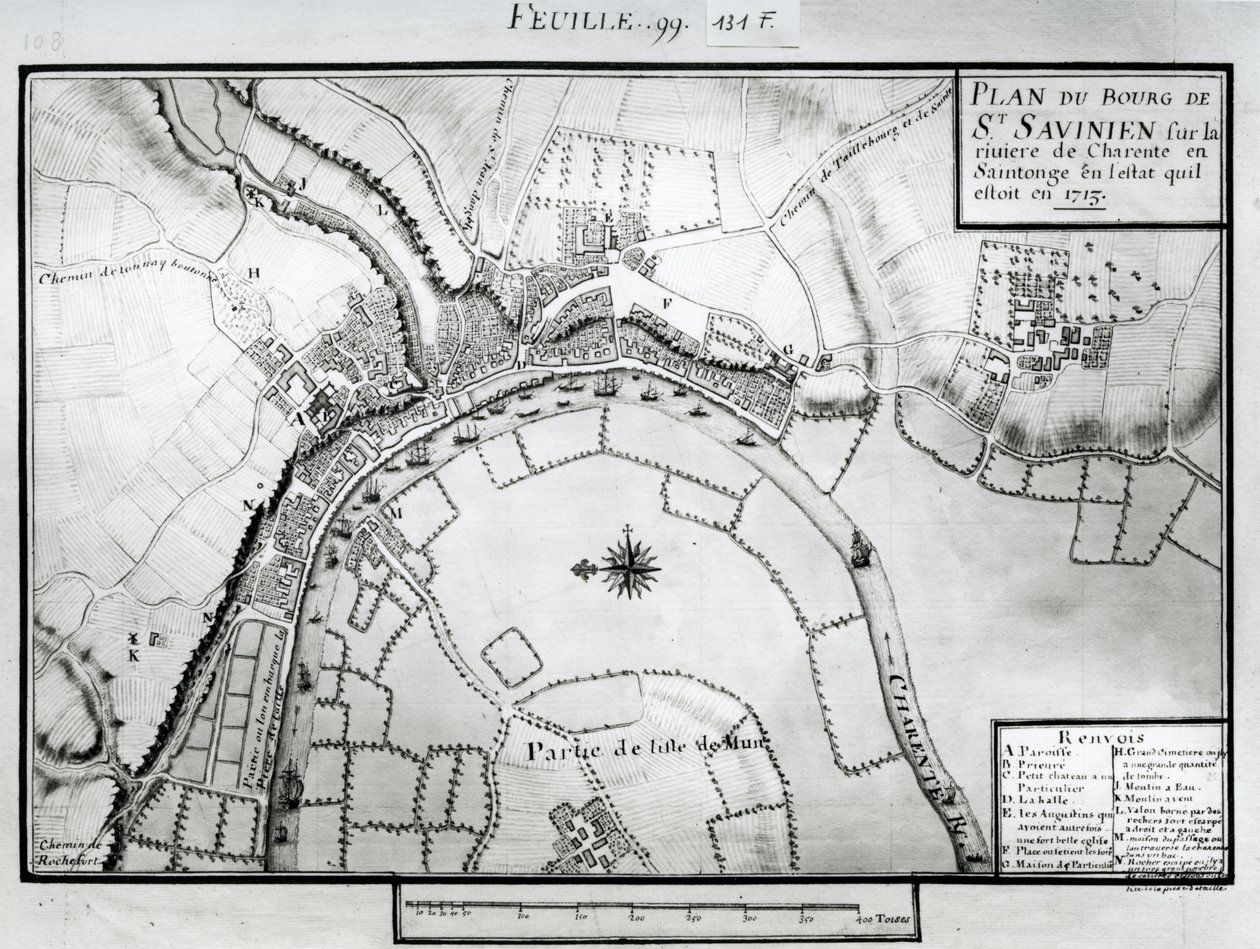
Map of Saint-Savinien on the Charente River in 1713, from

Map of Saint-Savinien on the Charente River in 1713, from 'Recueil des Plans de Saintonge'

(Fol.99 Map of Saint-Savinien on the Charente River in 1713, from 'Recueil des Plans de Saintonge' (pen und ink and wc on paper) )


Claude Masse

€ 115.42
Enthält 0% MwSt.
   Configure art print
Undated  ·  pen & ink and watercolour on paper  ·  Picture ID: 86163

Nonclassified artists  ·  Cartography

Map of Saint-Savinien on the Charente River in 1713, from 'Recueil des Plans de Saintonge' by Claude Masse. Available as an art print on canvas, photo paper, watercolor board, uncoated paper or Japanese paper.
aerial view · savinien · town · fields · province of western France · region · Min. Defense - Service Historique de l'Armee de Terre,France / Bridgeman Images
zu Favoriten hinzufügen   Add to favorites    Select wall color    View painting in a room AR/3D   View in 3D / AR

Note: Only reviews with comments are displayed. Reviews can be submitted directly after purchase in your customer account.

Configure art print

Picture Frame

Medium & Stretcher

Glass & Passepartout

Miscellaneous & Extras

 Save / compare configuration
Preview Icon

Summary

Gemälde
Veredelung
Keilrahmen
Museumslizenz

€ 115.42
(inkl. 20% MwSt)
   Add to cart

Bildschärfe: PERFEKT

Should you desire adjustments to brightness and color, or a custom crop of the motif, we are happy to make these changes at no additional cost to you. Please do not hesitate to contact us.

Similar artworks selected for you

Map of the town of Tonnay-Boutonne, from Recueil des Plans de Saintonge Atlas 131 fol.13 Map of Saintes, Capital of Saintonge, from Field Plan for the Battle of Arques Allersma - Map Apken 1822 A Map of Marylebone, London, 1746 A Map of The King Plan of Kensington Palace (detail) by Joshua Rhodes, 1764 A Map of Tothill Fields, London, 1746 Correct Survey of Dublin, As It Stood in the Year 1610 Plan of Richmond, Syon and Kew Promenades or Itineraries of the Gardens of Chantilly A Plan of the House and Gardens at Stowe, Buckinghamshire Siege of Bonn, 1703 Map of Westminster from Plan of the Villa del Poggio Imperiale Plan of Kensington Palace (detail) by Joshua Rhodes, 1764 Siege of Huy, 1705 Speculum Romanae Magnificentiae: Ancient Rome and its Hills, from the West A Map of Mile End and Stepney Green, London, 1746 A Map of Bloomsbury and Holborn, London A Map of Chelsea, 1746 Nuova pianta di Roma by Giambattista Nolli, 1748, known as La Pianta Grande di Roma New York City map of Naples with Capodimonte (detail) Hollar A Map of the Royal Palace and Gardens of Kensington, London, 1736 Siege of Ghent, 1708 Siege of Kaiserswerth, 1702 Plan of the City of Kaiserswerth Map of Suresnes and its annexe, Puteaux, 1669
Show more similar artworks

Other art prints by Claude Masse

Map of Saint-Savinien on the Charente River in 1713, from Map of the Town of Lille, from Atlas 131 fol.13 Map of Saintes, Capital of Saintonge, from Map of Bas Poitou, Pays d Map of part of Bas-Poitou and the Ile de Noirmoutier, 1703 Map of Bas Poitou, Pays d Map of Saintes, capital of Saintonge, from Receuil des Plans de Saintonge, 1716 Plan of Noirmoutier-en-l Plan of the Chateau de Forgette, near Saint-Savinien, from Map of the towns and chateaux situated along the Charente River in 1714, from Recueil des Plans de Saintonge Map of the town of Tonnay-Boutonne, from Recueil des Plans de Saintonge Map of Bas Poitou, Aunis and Saintonge with the Marshes of the Bay of Aiguillon in 1716 Plan of Saarlouis, from Traite de Fortifications Map of Saintonge, from Recueil des Plans de Saintonge Construction of a Town Square and the Tools Used
Discover more works by Claude Masse

Other motives from the category Cartography

Map of Luxembourg, from Map of the French Atlantic Coast and of England Map and Prospect of London, c.1710 Map of the Gold-Bearing Regions in Peru Map of India to New Guinea, c.1570-1603 Map of the Russian Empire, 1588 Map of the Cutch region of India and its border with neighbouring Baluchistan, by Carl Zimmerman, 1851 Map of the Battle of Cape St. Vincent, published by William Blackwood and Sons, Edinburgh and London, 1848 Europe and Central Asia, from an Atlas of the World in 33 Maps, Venice, 1st September 1553 Holy Roman Emperor (detail) Map of Africa, from Nova Africa Descriptio, published in Amsterdam by Dutch cartographer Frederik de Wit Map of the Suez Canal, c.1870 Map of Israel, from Map of the North Riding of Yorkshire Map of the world with possessions of the British Empire coloured red, c.1870
View More from "Cartography"

Excerpt from our top sellers

Women from Galicia at the Window The Luncheon: Monet Two Men Contemplating the Moon Beautiful Princess Bauhaus Staircase Emilie Floege Effect of Spring, Giverny, 1890 Carnation, Lily, Lily, Rose Horse Study Empress Eugenie Surrounded by her Ladies-in-Waiting, 1855 Landscape from Saint-Rémy Lady in Yellow The Wild Hunt of Odin Yacht Approaching the Coast View of the Naruto Whirlpools at Awa, from the Series
Show More Artworks


What our customers think about us


Frequently Asked Questions about Meisterdrucke


Personalizing your art print at Meisterdrucke is a simple and intuitive process that allows you to design an artwork exactly to your specifications: Choose a frame, determine the image size, decide on a printing medium, and add suitable glazing or a stretcher frame. We also offer customization options such as mats, fillets, and spacers. Our customer service is available to help you design your perfect artwork.

At Meisterdrucke, you have the fascinating option to visualize the artwork you configured directly in your own space. For a tailored preview, simply upload a photo of your room and let the artwork appear on it. If you visit us via a mobile device, be it a phone or tablet, our augmented reality feature brings the image to life and seamlessly projects it into your space. An experience that uniquely combines art and technology.

Choosing the medium is often a matter of personal taste. To give you a clearer idea, we have provided some images for each medium. For a holistic experience, we also offer you a sample set of all paper variants so you can make a decision not just visually but also haptically. You can take advantage of the sample set free of charge – only the shipping costs will apply. You can order the sample set directly.

Do not worry. At Meisterdrucke, we do not proceed mechanically. We manually review each order. If there are any inconsistencies or peculiarities in the configuration, we will immediately contact you. Of course, our courteous and patient support is always at your side to assist you with the configuration. Together with you, we adjust your image by phone or email so that the final result exactly meets your expectations.


Do you have any questions?

Are you interested in an art print from our manufactory but still unsure? Do you need advice on choosing the medium or help with the order?

Our experts are happy to assist you.

+43 4257 29415
support@meisterdrucke.com
Mo-Do: 7:00 - 16:00 | Fr: 7:00 - 13:00

Do you have any questions?

Are you interested in an art print from our manufactory but still unsure? Do you need advice on choosing the medium or help with the order?

Our experts are happy to assist you.

+43 4257 29415
support@meisterdrucke.com
Mo-Do: 7:00 - 16:00 | Fr: 7:00 - 13:00


Meisterdrucke

   Kärntner Strasse 46
        9586 Finkenstein am Faaker See
        Austria
        +43 4257 29415
        support@meisterdrucke.com
Other languages

                   
Erfahrungen & Bewertungen zu Meisterdrucke
Partner Logos

Kaiser Franz Joseph

Meisterdrucke
Kärntner Strasse 46
9586 Finkenstein am Faaker See · Austria
+43 4257 29415 · office@meisterdrucke.com
Partner Logos


(c) 2025 meisterdrucke.uk