Search by artist, work title or style – e.g. Monet, Starry Night, Impressionism, Hokusai wave, nude. Describe the scene – e.g. green meadow, abstract with lots of red, dark oil painting, standing nude next to a tree.

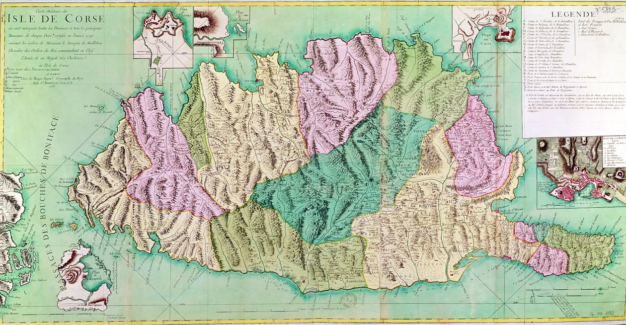
Military Map of Corsica by French School

Military Map of Corsica

(Military map of Corsica, 1768 )


French School

€ 105.73
Enthält 0% MwSt.
   Configure art print
1768  ·  coloured engraving  ·  Picture ID: 57814

Cultural Circles  ·  Cartography

Military Map of Corsica by French School. Available as an art print on canvas, photo paper, watercolor board, uncoated paper or Japanese paper.
island · geographic · Bibliotheque Nationale, Paris, France / Bridgeman Images
AR/3D   View in 3D / AR zu Favoriten hinzufügen   Add to favorites    Select wall color    View painting in a room
0 Reviews

Configure art print

Picture Frame

Medium & Stretcher

Glass & Passepartout

Miscellaneous & Extras

 Save / compare configuration
Preview Icon

Summary

Gemälde
Veredelung
Keilrahmen
Museumslizenz

€ 105.73
(inkl. 20% MwSt)
   Add to cart

Bildschärfe: PERFEKT

Should you desire adjustments to brightness and color, or a custom crop of the motif, we are happy to make these changes at no additional cost to you. Please do not hesitate to contact us.

Similar artworks selected for you

The Chain of Mont Blanc, from an actual survey in 1863 by A. Adams Reilly, published in A Record of Mountain Adventure and Scientific Observation for the Alpine Club, 1865 Aragon, Catalonia, Valencian Community, Murcia, Andalusia, Castile-La Mancha and Balearic Islands, Spain Map of the South Territories of the Duke of Savoy, in Italy Alsace, France Historical Map of the Italian Region Where the Etruscans Lived After the Atlas of G. Delisle Gulf of Venice to Tirol, centered on Lago di Garda and Verona, Italy (engraving) Provence-Alpes-Côte d Sicily, Italy (engraving) La Rioja, Navarre, Aragon, Catalonia, Valencian Community, Castile-La Mancha, Madrid, Castile and León, Spain Map of Corsica (France) (etching) Map of the Kingdom of Hungary, Printed by Godfried Galicia, Spain Land Map of the Electorate of Brandenburg with Royal Prussian Privilege Ancona and Spoleto, Italy (engraving) Isle of Corsica, France Fossa Eugeniana Begun in 1627 Under the Command of Count Hendrik van den Bergh Corsica, France Center of Italy - by A Map of Cutch and Bombay Presidency, India, 1898 Chart of the Island of Timor Brittany and Normandy, France (engraving) South Piedmont and Monferrato, Italy Crown of Portugal and Algarve, Formerly Part of Old Hispania, Now Divided into Provinces and Dioceses Portugal Galicia, Principado de Asturias, Cantabria, Castile and León, Spain Gulf of Valencia (Aragon), Spain Beauvais, France (engraving) Geographic map of Algeria and details of the provinces of Algiers, Oran and Constantine, realized by Amboise Tardieu Lakes in Switzerland (engraving)
Show more similar artworks

Other art prints by French School

Birth of Jesus, from the Book of Hours of the Master of Jacques de Besançon Genealogical Tree of the Rougon-Macquart Family Poster Advertising the Baron Hotel in Aleppo The Shield of Achilles, After the Description in Homer Beef: Diagram Depicting the Different Cuts of Meat The Carte du Tendre, a map of an imaginary country, from volume II of Clelie written by Mademoiselle de Scudery, engraved by Francois Chauveau (1613-76) 1656 Reproduction of Map of Routes of St. James of Compostel, Originally Engraved by D. Serveaux 1648 Poster advertising Pur Champagne, from Damery, Epernay Lyrics to Poster advertising Maggi The Man with Six Heads, Caricature of Charles Maurice de Talleyrand-Perigord, 1815 Veal: diagram depicting the different cuts of meat Cuts of Pork, illustration from a French Domestic Science Manual by H. de Puytorac, published by Editions Fernand Nathan, late 19th century Frederic Chopin (1810-49) Engraved from a Daguerrotype Equestrian Statue of Charlemagne (742-814)
Discover more works by French School

Other motives from the category Cartography

The Polar Aurora, from a Drawing for the map of the moon Map of the Western Mediterranean Map of Luneburg, from Map of Africa, Published in 1700, Paris Map Showing the Geography of the Hebrews and Exhibiting the Dispersion of the Descendants of Noah Map of WRATISLAVA Bresslaw, from Map showing the localities of the Indian tribes of the US in 1833, illustration from Map of Northern Europe, from Map of America, 1878 Map of Palmanova, from Les Villes de Venetie, 1704, published by Rutgert Alberts in the Hague Map of Paris at the Outbreak of the French Revolution, published by William Blackwood and Sons Maps Made during the Voyage of a Vietnamese Embassy to China The Continent of Europe, from an Atlas of the World in 33 Maps, Venice, 1st September 1553 Map of Constantinople and Surrounding Areas, 1855-63
View More from "Cartography"

Excerpt from our top sellers

Orchard with Roses Young Hare The Hay Wain Red Balloon Beaulieu: The Bay of Fourmis The Fall of the Damned The Tower of Babel (Vienna) View of Vétheuil. 1880 Morning amongst the Coniston Fells, Cumberland The Crucifixion, from the Isenheim Altarpiece Cosmic Cliffs in the Carina Nebula Stag Beetle Knight, Death and the Devil, 1513 Boys Bathing Dancer (Die Tänzerin), 1913
Show More Artworks


What our customers think about us


Frequently Asked Questions about Meisterdrucke


Personalizing your art print at Meisterdrucke is a simple and intuitive process that allows you to design an artwork exactly to your specifications: Choose a frame, determine the image size, decide on a printing medium, and add suitable glazing or a stretcher frame. We also offer customization options such as mats, fillets, and spacers. Our customer service is available to help you design your perfect artwork.

At Meisterdrucke, you have the fascinating option to visualize the artwork you configured directly in your own space. For a tailored preview, simply upload a photo of your room and let the artwork appear on it. If you visit us via a mobile device, be it a phone or tablet, our augmented reality feature brings the image to life and seamlessly projects it into your space. An experience that uniquely combines art and technology.

Choosing the medium is often a matter of personal taste. To give you a clearer idea, we have provided some images for each medium. For a holistic experience, we also offer you a sample set of all paper variants so you can make a decision not just visually but also haptically. You can take advantage of the sample set free of charge – only the shipping costs will apply. You can order the sample set directly.

Do not worry. At Meisterdrucke, we do not proceed mechanically. We manually review each order. If there are any inconsistencies or peculiarities in the configuration, we will immediately contact you. Of course, our courteous and patient support is always at your side to assist you with the configuration. Together with you, we adjust your image by phone or email so that the final result exactly meets your expectations.


Do you have any questions?

Are you interested in an art print from our manufactory but still unsure? Do you need advice on choosing the medium or help with the order?

Our experts are happy to assist you.

+43 4257 29415
support@meisterdrucke.com
Mo-Do: 7:00 - 16:00 | Fr: 7:00 - 13:00

Do you have any questions?

Are you interested in an art print from our manufactory but still unsure? Do you need advice on choosing the medium or help with the order?

Our experts are happy to assist you.

+43 4257 29415
support@meisterdrucke.com
Mo-Do: 7:00 - 16:00 | Fr: 7:00 - 13:00


Meisterdrucke

   Kärntner Strasse 46
        9586 Finkenstein am Faaker See
        Austria
        +43 4257 29415
        support@meisterdrucke.com
Other languages

                   
Erfahrungen & Bewertungen zu Meisterdrucke
Post.at DHL Express Quehenberger Cargoboard
Kaiser Franz Joseph

Meisterdrucke
Kärntner Strasse 46
9586 Finkenstein am Faaker See · Austria
+43 4257 29415 · office@meisterdrucke.com
Post.at DHL Express Quehenberger Cargoboard


Meisterdrucke 2759 Bewertungen auf ProvenExpert.com

(c) 2025 meisterdrucke.uk