Search by artist, work title or style – e.g. Monet, Starry Night, Impressionism, Hokusai wave, nude. Describe the scene – e.g. green meadow, abstract with lots of red, dark oil painting, standing nude next to a tree.

Map of Sixteenth Century Scandinavia, from the

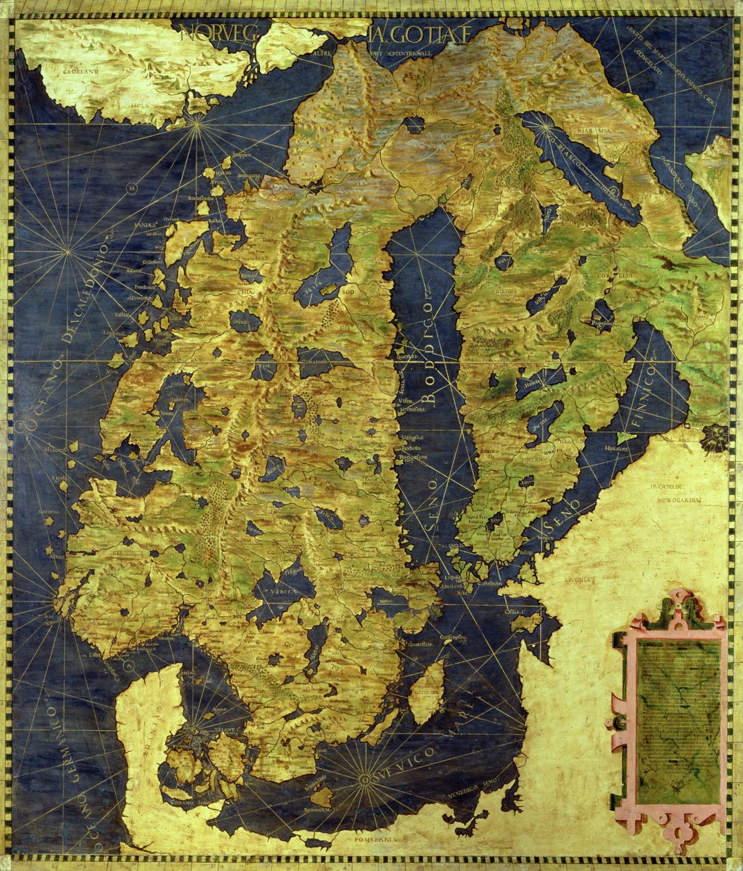
Map of Sixteenth Century Scandinavia, from the 'Sala delle Carte Geografiche' (Hall of Geographical Maps) 1575

(Map of Sixteenth Century Scandinavia, from the 'Sala delle Carte Geografiche' (Hall of Geographical Maps) 1575 )


Stefano and Danti, Egnazio Bonsignori

€ 111.16
Enthält 0% MwSt.
   Configure art print
1575  ·  Öl auf Holz  ·  Picture ID: 149693

Nonclassified artists  ·  Cartography

Map of Sixteenth Century Scandinavia, from the 'Sala delle Carte Geografiche' (Hall of Geographical Maps) 1575 by Stefano and Danti, Egnazio Bonsignori. Available as an art print on canvas, photo paper, watercolor board, uncoated paper or Japanese paper.
cartography · norway · denmark · sweden · gulf of bothnia · baltic sea · norwegian sea · Palazzo Vecchio (Palazzo della Signoria) Florence, Italy / Bridgeman Images
Other color variations of this picture  
AR/3D   View in 3D / AR zu Favoriten hinzufügen   Add to favorites    Select wall color    View painting in a room
0 Reviews

Configure art print

Picture Frame

Medium & Stretcher

Glass & Passepartout

Miscellaneous & Extras

 Save / compare configuration
Preview Icon

Summary

Gemälde
Veredelung
Keilrahmen
Museumslizenz

€ 111.16
(inkl. 20% MwSt)
   Add to cart

Bildschärfe: PERFEKT

Should you desire adjustments to brightness and color, or a custom crop of the motif, we are happy to make these changes at no additional cost to you. Please do not hesitate to contact us.

Similar artworks selected for you

Iceland Map of the Bay of Bengal, the China Sea and Java Karelia and Northern Russia Map of Sixteenth Century France, from the Anatolian Peninsula with Ancient Toponyms and Middle East Russia Moscovia Frontier of the West Indies and Unknown Lands Map Made by Egnazio Danti (1536-1586) Mathematician, Cosmographer and Italian Architect. Around 1567. Florence, Palazzo Vecchio, Sala del Mappamondo Map of the Cape of Good Hope Scandinavia, detail from the Carta Marina by Olaus Magnus Anatolia Map Made by Egnazio Danti Scandinavia (detail) The British Isles Map of Sixteenth Century Europe, from the Map of Northern Europe, from Map of Sixteenth Century Britain and Northern France, from the 1593 Map of Northern Europe A Faithful Reproduction of Carta Marina (A Wallmap of Scandinavia by Olaus Magnus Published in 1539) Map of France, Spain and North-West Africa, from the Northern Europe, from an Atlas of the World in 33 maps, Venice, 1st September 1553 (ink on vellum) Map of Sixteenth Century Japan (from the Map of Europe Map of the Sixteenth Century British Isles, from the Italy France South Africa, Mozambique and Part of Madagascar California Indochinese Peninsula and Major Islands of Indonesia
Show more similar artworks

Other motives from the category Cartography

A Map of the West End and Soho, London, 1746 Map of the Mediterranean, 1625 Map of Tenochtitlan and the Gulf of Mexico, from Praeclara Ferdinadi Cortesii de Nova maris Oceani Hyspania Narratio by Hernando Cortes (1485-1547) 1524 Map of the Austro-Hungarian empire, illustration from a French geography school textbook, 1905 Map of the Northern Sky with Representations of the Constellations Map of the Acropolis of the 2nd city at Troy An Astronomer, detail from a map of the planets, from Map of European Russia showing its Earliest Extent, its Encroachments upon Adjacent Countries, and the Present Boundary of the Empire Phenomena of Aratus, cosmological diagram Map of France depicting the departmental divisions, 1798 Map of Southern Africa (published in Strasbourg in 1522) Map of Algeria Galathes, 11th King of the Gauls with a map of Gaul behind, detail from a tapestry on the history of the Kings of the Gauls, Arras Workshop, c.1530 A Map of St. James Map of Florence, 1584
View More from "Cartography"

Excerpt from our top sellers

The Songs of the Night The Langlois Bridge at Arles with Washerwomen The Goldfinch Cupid and Psyche The Japanese Bridge La Primavera Haymaking Bridge in Monet The Deluge Genealogical Tree of the Rougon-Macquart Family The Kiss The Great Piece of Turf View on Delft The Birth of Venus Blue
Show More Artworks


What our customers think about us


Frequently Asked Questions about Meisterdrucke


Personalizing your art print at Meisterdrucke is a simple and intuitive process that allows you to design an artwork exactly to your specifications: Choose a frame, determine the image size, decide on a printing medium, and add suitable glazing or a stretcher frame. We also offer customization options such as mats, fillets, and spacers. Our customer service is available to help you design your perfect artwork.

At Meisterdrucke, you have the fascinating option to visualize the artwork you configured directly in your own space. For a tailored preview, simply upload a photo of your room and let the artwork appear on it. If you visit us via a mobile device, be it a phone or tablet, our augmented reality feature brings the image to life and seamlessly projects it into your space. An experience that uniquely combines art and technology.

Choosing the medium is often a matter of personal taste. To give you a clearer idea, we have provided some images for each medium. For a holistic experience, we also offer you a sample set of all paper variants so you can make a decision not just visually but also haptically. You can take advantage of the sample set free of charge – only the shipping costs will apply. You can order the sample set directly.

Do not worry. At Meisterdrucke, we do not proceed mechanically. We manually review each order. If there are any inconsistencies or peculiarities in the configuration, we will immediately contact you. Of course, our courteous and patient support is always at your side to assist you with the configuration. Together with you, we adjust your image by phone or email so that the final result exactly meets your expectations.


Do you have any questions?

Are you interested in an art print from our manufactory but still unsure? Do you need advice on choosing the medium or help with the order?

Our experts are happy to assist you.

+43 4257 29415
support@meisterdrucke.com
Mo-Do: 7:00 - 16:00 | Fr: 7:00 - 13:00

Do you have any questions?

Are you interested in an art print from our manufactory but still unsure? Do you need advice on choosing the medium or help with the order?

Our experts are happy to assist you.

+43 4257 29415
support@meisterdrucke.com
Mo-Do: 7:00 - 16:00 | Fr: 7:00 - 13:00


Meisterdrucke

   Kärntner Strasse 46
        9586 Finkenstein am Faaker See
        Austria
        +43 4257 29415
        support@meisterdrucke.com
Other languages

                   
Erfahrungen & Bewertungen zu Meisterdrucke
Post.at DHL Express Quehenberger Cargoboard
Kaiser Franz Joseph

Meisterdrucke
Kärntner Strasse 46
9586 Finkenstein am Faaker See · Austria
+43 4257 29415 · office@meisterdrucke.com
Post.at DHL Express Quehenberger Cargoboard


Meisterdrucke 2752 Bewertungen auf ProvenExpert.com

(c) 2025 meisterdrucke.uk