Search by artist, work title or style – e.g. Monet, Starry Night, Impressionism, Hokusai wave, nude. Describe the scene – e.g. green meadow, abstract with lots of red, dark oil painting, standing nude next to a tree.

Map of Belgium at the Time of the Thirty Years War, from the

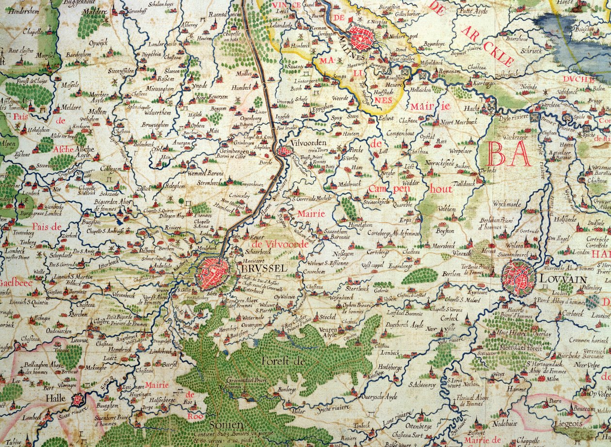
Map of Belgium at the Time of the Thirty Years War, from the 'Theatre des guerres entre le roy d'Espagne et les Estats de Hollande' (known as the 'Atlas de Richelieu')

(Map of Belgium at the time of the Thirty Years War (1618-48), from the 'Theatre des guerres entre le roy d'Espagne et les Estats de Hollande' (known as the 'Atlas de Richelieu' )


Arnold Florent van Langren

€ 122.86
Enthält 0% MwSt.
   Configure art print
Undated  ·  coloured engraving  ·  Picture ID: 187666

Nonclassified artists  ·  Cartography

Map of Belgium at the Time of the Thirty Years War, from the 'Theatre des guerres entre le roy d'Espagne et les Estats de Hollande' (known as the 'Atlas de Richelieu') by Arnold Florent van Langren. Available as an art print on canvas, photo paper, watercolor board, uncoated paper or Japanese paper.
brussels and leuven · brussels · low countries · netherlands · holland · brussels · brussels · franders · Archives du Ministere des Affaires Etrangeres, Paris, France / Bridgeman Images
AR/3D   View in 3D / AR zu Favoriten hinzufügen   Add to favorites    Select wall color    View painting in a room
0 Reviews

Configure art print

Picture Frame

Medium & Stretcher

Glass & Passepartout

Miscellaneous & Extras

 Save / compare configuration
Preview Icon

Summary

Gemälde
Veredelung
Keilrahmen
Museumslizenz

€ 122.86
(inkl. 20% MwSt)
   Add to cart

Bildschärfe: PERFEKT

Should you desire adjustments to brightness and color, or a custom crop of the motif, we are happy to make these changes at no additional cost to you. Please do not hesitate to contact us.

Similar artworks selected for you

Map of Flanders at the Time of the Thirty Years War (1618-48), from Franciae Orientalis (Vulgo/Franckenlant) Descriptio, Auctore Sebast. A. Rotenhan. Geography Map of the Territory of Franconia in Germany with the City of Frankfurt (also the City of Karlstadt) Taken from Map of the Diocese of Liege (Belgium) Belgium, Netherlands Champagne - Cambresis - Picardy - Normandy and Brittany, in Geography Map of Poland from Theatrum Orbis Terrarum by Abraham Ortelius State: Bavaria, Germany Map of Lazio Region, from Theatrum Orbis Terrarum State: Hesse, Thuringia, Bavaria, Baden-Württemberg, Germany Picardy, Nord-Pas de Calais, France Geography map of Saxonia and Thuringia from Typus Vindeliciae Ssive Utriusque Bavariae: Secundum Antiquam & Recentiorum Situm, ab Joanne Aventino Olim Descriptus... Geography Map of the Territory of Bavaria in Germany from Poland, Lithuania, Belarus, South-West Russia, West Ukraine, North Moldova, Slovakia Geography map of the Duke of Milan from Switzerland (engraving) Map of the area around Bordeaux (France) Belgium, South Holland Germany, Poland, Czech Republic Map of Wurttemberg, from Theatrum Orbis Terrarum by Abraham Ortelius West Czech Republic, Germany Geography map of the territory of Bohemia from Map of Saxony, from Theatrum Orbis Terrarum Romania Map of Friuli Venezia Giulia Region, from Theatrum Orbis Terrarum by Abraham Ortelius Castillia with Madrid and Toledo, Spain (engraving) Map of Syria, after the death of Alexander the Great Aragon and Catalonia, Spain (engraving) Map of Savoie, from Theatrum Orbis Terrarum by Abraham Ortelius Lorraine, France (engraving)
Show more similar artworks

Other motives from the category Cartography

Map of Charles V, Map of Mecia de Viladestes, a portulan of Europe and North Africa, 1413 Map of the Voyage of the Argonauts, from the Map of Southern Italy, Corsica, and Sardinia Known in Ancient Times as Great Greece or Magnia Graecia Map of the world with possessions of the British Empire coloured red, c.1870 Map from De La Situation du Paradis Terrestre, 1691 Detail of Copy of a Catalan Map of Europe and North Africa, presented to Charles V of France in 1381 Map of the Eastern Part of the Roman Empire, from A Map of Clerkenwell, City of London, 1746 Plan of Paris, under the Reign of Henry II by Olivier Truschet and Germain Hoyau A Map of Mile End and Stepney Green, London, 1746 Map of Cutch and Bombay Presidency, India, 1898 A Map Showing the Passage of the Shadow of the Moon Over England on 22 April 1715, Engraved by John Senex, 1715 Map of the St. Lawrence Estuary Part of the Tabula Peutingeriana, an illustrated itinerarium of the road network in the Roman Empire. Detail of Italy from the Peutinger map copy Map of Paris depicting the city
View More from "Cartography"

Excerpt from our top sellers

A Street at Night Church in Cassone Young Hare Irises Dante and Virgil Still Life with Coffee The Three Sisters on the Beach Flowers in a Crystal Vase Trees and Undergrowth, 1887 After the Bath Sack of Rome (455) - The Destiny of Empires - Destruction - by Thomas Cole - 1836- New York Historical Society - (Rome, Roman Empire, Gaiseric, Genseric, Migration Period, Barbarian Invasions, Vandals, Fall of Western Roman Empire, Fall of Rome, Sack of Ro A Vase of Roses The Goldfinch Beach Study The Family
Show More Artworks


What our customers think about us


Frequently Asked Questions about Meisterdrucke


Personalizing your art print at Meisterdrucke is a simple and intuitive process that allows you to design an artwork exactly to your specifications: Choose a frame, determine the image size, decide on a printing medium, and add suitable glazing or a stretcher frame. We also offer customization options such as mats, fillets, and spacers. Our customer service is available to help you design your perfect artwork.

At Meisterdrucke, you have the fascinating option to visualize the artwork you configured directly in your own space. For a tailored preview, simply upload a photo of your room and let the artwork appear on it. If you visit us via a mobile device, be it a phone or tablet, our augmented reality feature brings the image to life and seamlessly projects it into your space. An experience that uniquely combines art and technology.

Choosing the medium is often a matter of personal taste. To give you a clearer idea, we have provided some images for each medium. For a holistic experience, we also offer you a sample set of all paper variants so you can make a decision not just visually but also haptically. You can take advantage of the sample set free of charge – only the shipping costs will apply. You can order the sample set directly.

Do not worry. At Meisterdrucke, we do not proceed mechanically. We manually review each order. If there are any inconsistencies or peculiarities in the configuration, we will immediately contact you. Of course, our courteous and patient support is always at your side to assist you with the configuration. Together with you, we adjust your image by phone or email so that the final result exactly meets your expectations.


Do you have any questions?

Are you interested in an art print from our manufactory but still unsure? Do you need advice on choosing the medium or help with the order?

Our experts are happy to assist you.

+43 4257 29415
support@meisterdrucke.com
Mo-Do: 7:00 - 16:00 | Fr: 7:00 - 13:00

Do you have any questions?

Are you interested in an art print from our manufactory but still unsure? Do you need advice on choosing the medium or help with the order?

Our experts are happy to assist you.

+43 4257 29415
support@meisterdrucke.com
Mo-Do: 7:00 - 16:00 | Fr: 7:00 - 13:00


Meisterdrucke

   Kärntner Strasse 46
        9586 Finkenstein am Faaker See
        Austria
        +43 4257 29415
        support@meisterdrucke.com
Other languages

                   
Erfahrungen & Bewertungen zu Meisterdrucke
Post.at DHL Express Quehenberger Cargoboard
Kaiser Franz Joseph

Meisterdrucke
Kärntner Strasse 46
9586 Finkenstein am Faaker See · Austria
+43 4257 29415 · office@meisterdrucke.com
Post.at DHL Express Quehenberger Cargoboard


Meisterdrucke 2755 Bewertungen auf ProvenExpert.com

(c) 2025 meisterdrucke.uk