Search by artist, work title or style – e.g. Monet, Starry Night, Impressionism, Hokusai wave, nude. Describe the scene – e.g. green meadow, abstract with lots of red, dark oil painting, standing nude next to a tree.

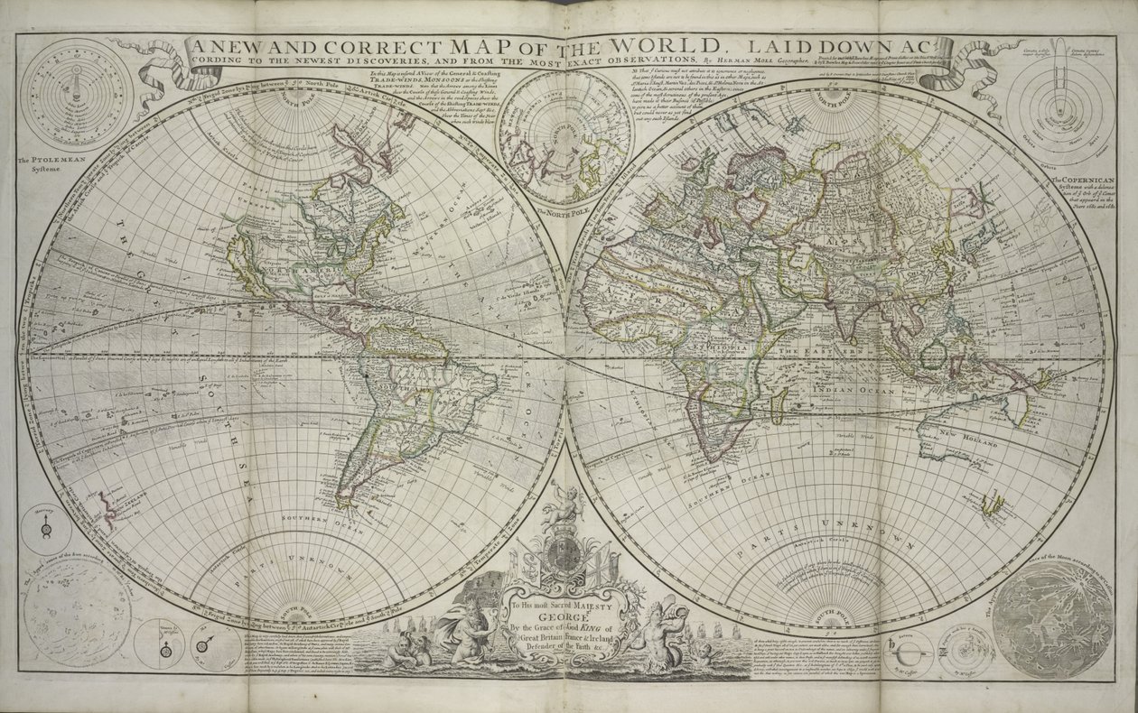
A new and correct map of the world laid down according to the newest discoveries and from the most exact observations by Hermann Moll

A new and correct map of the world laid down according to the newest discoveries and from the most exact observations

(A new and correct map of the world laid down according to the newest discoveries and from the most exact observations, 1736 (hand coloured print))


Hermann Moll

€ 115.23
Enthält 0% MwSt.
   Configure art print
1736  ·  hand coloured print  ·  Picture ID: 135768

Nonclassified artists  ·  Cartography

A new and correct map of the world laid down according to the newest discoveries and from the most exact observations by Hermann Moll. Available as an art print on canvas, photo paper, watercolor board, uncoated paper or Japanese paper.
New York Public Library, USA / Bridgeman Images
Other color variations of this picture  
AR/3D   View in 3D / AR zu Favoriten hinzufügen   Add to favorites    Select wall color    View painting in a room

Note: Only reviews with comments are displayed. Reviews can be submitted directly after purchase in your customer account.

Configure art print

Picture Frame

Medium & Stretcher

Glass & Passepartout

Miscellaneous & Extras

 Save / compare configuration
Preview Icon

Summary

Gemälde
Veredelung
Keilrahmen
Museumslizenz

€ 115.23
(inkl. 20% MwSt)
   Add to cart

Bildschärfe: PERFEKT

Should you desire adjustments to brightness and color, or a custom crop of the motif, we are happy to make these changes at no additional cost to you. Please do not hesitate to contact us.

Similar artworks selected for you

Map of the Two Hemispheres Geo-Hydrographic Mappamonde World Map, Drawn from Observations of the Royal Academy of Sciences and Others A New Map of the World in Two Hemispheres with the New Discoveries & Tracts of the Two Circum Navigators Dampier & Anson Planisphere World Trade card for H Moll A New and Accurate Map of the World Maps and Plans of America A General Map of the World or Terraqueous Globe by Samuel Dunn, 1787 Map of the Whole World Map of the Whole World - Adorned According to the Observations of the Royal Academy of Sciences and Some Others According to the Latest Annotations Relief Shown Pictorially World Map Two Hemisphere World Map General Map of the Earth World Map for the King The World, image taken from page 17 of Map of the World, 1631 Cartesian Map of Hemispheres The world, by A.H. Jaillot in Map of the World in two Hemispheres, from Map of the World Planiglobii Terrestris Mappa Universalis A new map of the whole world with the trade winds according to the latest and most exact observations A Map of the World, Corrected from the Observations Communicated to the Royal Societies of London and Paris, to the Right Honourable Richard Boyle Two hemispheres Map of the World in Hemispheres
Show more similar artworks

Other art prints by Hermann Moll

A new and correct map of the world laid down according to the newest discoveries and from the most exact observations Map of the Caribbean, 1715 The Empire of China and Island of Japan Map of The West Part of Barbary, c.1720 Map of South America, c.1715 Map of the Dominions of Great Britain in North America, 1711 A New and Correct Map of the World, Laid Down According to the Newest Discoveries, and from the Most Exact Observations, by Herman Moll, Geographer Map of Spain and Portugal Congo. Angola. Cafres. Monoemugi. Monomotapa. Zanguebar & Madagascar, 1701 The Turkish Empire in Europe, Asia and Africa Village of the Susquehanna People, Susquehanna River (detail) published as inset in Hermann Moll A View of the General and Coasting Trade-Winds, Monsoons or the Shifting Trade Winds Through the World, Variations... According to the Newest and Most Exact Observations Map of Africa, c.1715 A New and Exact Map of the Coast Countries and Islands Within Ye Limits of Ye South Sea Company A Chart of the Sea Coast from England to the Straits
Discover more works by Hermann Moll

Other motives from the category Cartography

Map of Florida, c.1584 A Sailing Ship Firing Its Cannon, Detail from a Map of the Pacific, China and America, 1599 American Indian Map Australia, from a Series of World Maps Published by John Tallis and Co., London and New York, 1850s Map of North and South America, from the Map of Sas van Gent, Netherlands Typus Orbis Terrarum, map of the world, from Ortelius Map of Africa, Published in 1700, Paris Map of Lucca and Pisa, Tuscany, Italy Map of the Scene of War on the Danube Map of the United States in 1803, from Our Whole Country: The Past and Present of the United States, Historical and Descriptive, by John Warner Barber and Henry Hare, 1861 Map of London in the 11th Century Map of the Russian empire in the sixteenth century, copy of an original of 1571 Map of Brazil Map of Florence (detail)
View More from "Cartography"

Excerpt from our top sellers

The Roses of Heliogabalus A Guardian Angel Protects Two Children Crossing a River on an Old Wooden Bridge, Early 20th Century After the Bath A Tower of Blue Horses The Equatorial Jungle, 1909 Wiltshire Landscape, 1937 Daniel in the Lions Den Coffee Garden at Ammersee Portrait of the Artist The Cave of the Storm Nymphs Kite Flying Watercolor No. 606 Mars and Venus, Allegory of Peace View of a Harbor The Seven Works of Mercy
Show More Artworks


What our customers think about us


Frequently Asked Questions about Meisterdrucke


Personalizing your art print at Meisterdrucke is a simple and intuitive process that allows you to design an artwork exactly to your specifications: Choose a frame, determine the image size, decide on a printing medium, and add suitable glazing or a stretcher frame. We also offer customization options such as mats, fillets, and spacers. Our customer service is available to help you design your perfect artwork.

At Meisterdrucke, you have the fascinating option to visualize the artwork you configured directly in your own space. For a tailored preview, simply upload a photo of your room and let the artwork appear on it. If you visit us via a mobile device, be it a phone or tablet, our augmented reality feature brings the image to life and seamlessly projects it into your space. An experience that uniquely combines art and technology.

Choosing the medium is often a matter of personal taste. To give you a clearer idea, we have provided some images for each medium. For a holistic experience, we also offer you a sample set of all paper variants so you can make a decision not just visually but also haptically. You can take advantage of the sample set free of charge – only the shipping costs will apply. You can order the sample set directly.

Do not worry. At Meisterdrucke, we do not proceed mechanically. We manually review each order. If there are any inconsistencies or peculiarities in the configuration, we will immediately contact you. Of course, our courteous and patient support is always at your side to assist you with the configuration. Together with you, we adjust your image by phone or email so that the final result exactly meets your expectations.


Do you have any questions?

Are you interested in an art print from our manufactory but still unsure? Do you need advice on choosing the medium or help with the order?

Our experts are happy to assist you.

+43 4257 29415
support@meisterdrucke.com
Mo-Do: 7:00 - 16:00 | Fr: 7:00 - 13:00

Do you have any questions?

Are you interested in an art print from our manufactory but still unsure? Do you need advice on choosing the medium or help with the order?

Our experts are happy to assist you.

+43 4257 29415
support@meisterdrucke.com
Mo-Do: 7:00 - 16:00 | Fr: 7:00 - 13:00


Meisterdrucke

   Kärntner Strasse 46
        9586 Finkenstein am Faaker See
        Austria
        +43 4257 29415
        support@meisterdrucke.com
Other languages

                   
Erfahrungen & Bewertungen zu Meisterdrucke
Post.at DHL Express Quehenberger Cargoboard
Kaiser Franz Joseph

Meisterdrucke
Kärntner Strasse 46
9586 Finkenstein am Faaker See · Austria
+43 4257 29415 · office@meisterdrucke.com
Post.at DHL Express Quehenberger Cargoboard


Meisterdrucke 2745 Bewertungen auf ProvenExpert.com

(c) 2025 meisterdrucke.uk