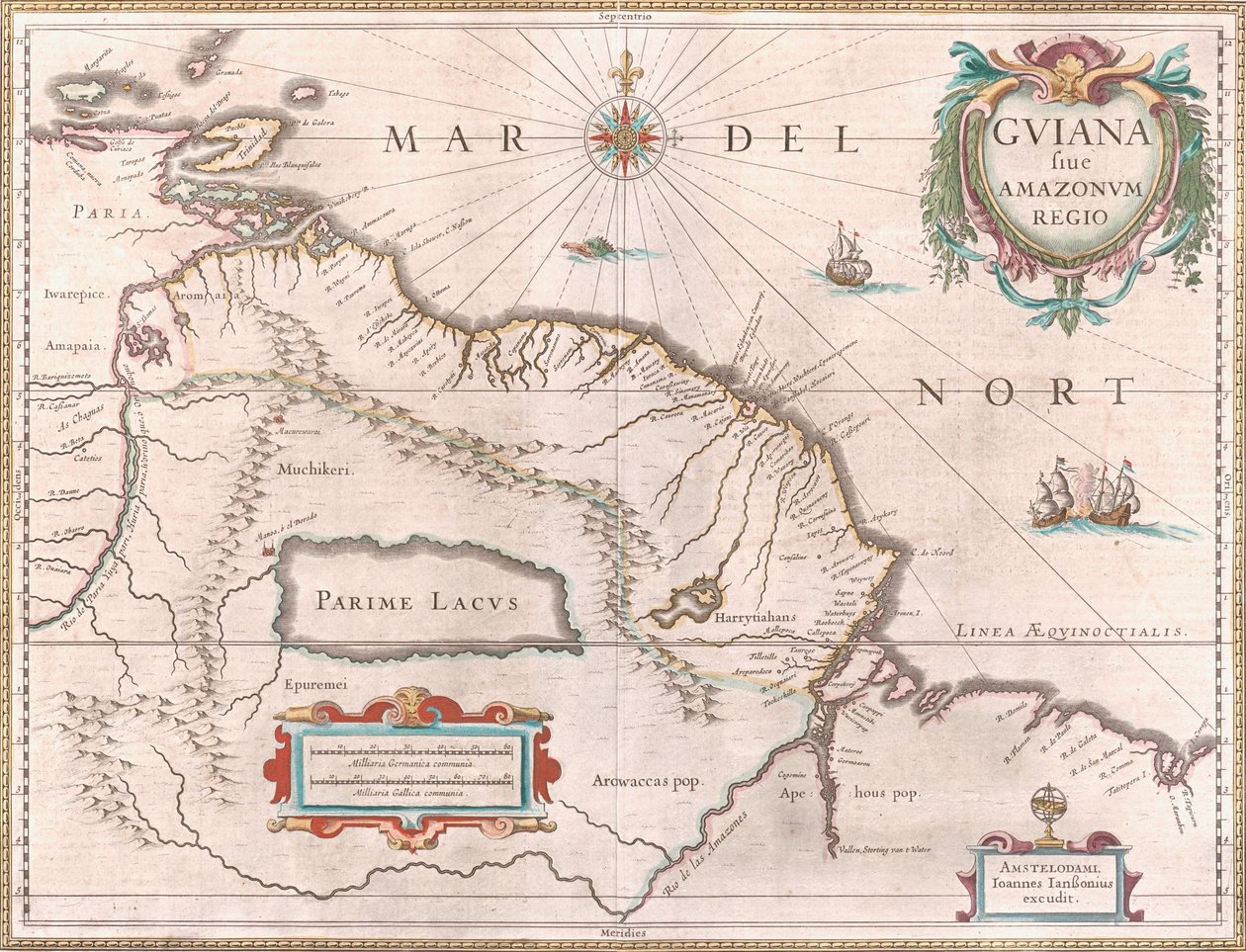
Map of the Guiana Region circa 1649 by Jan Janssonius

Map of the Guiana Region circa 1649

(A map created circa 1649 depicting the Guiana region. Territory claimed by Spain in red to the west, Dutch Guiana highlighted in yellow and Portuguese territory in red to the southeast. The mythical Lake Parime is also visible)


Jan Janssonius

€ 0.00
Enthält ??% MwSt.
   Add to cart
   Configure art print
1649  ·  Unbekannt  ·  Picture ID: 1394880

Nonclassified artists

Map of the Guiana Region circa 1649 by Jan Janssonius. Available as an art print on canvas, photo paper, watercolor board, uncoated paper or Japanese paper.
zu Favoriten hinzufügen   Add to favorites    Select wall color    View painting in a room AR/3D   View in 3D / AR
0 Reviews

Configure art print

Picture Frame

Medium & Stretcher

Glass & Passepartout

Miscellaneous & Extras

 Save / compare configuration
Preview Icon

Summary

Gemälde
Veredelung
Keilrahmen
Museumslizenz

€ 102.34
(inkl. 20% MwSt)
   Add to cart

Bildschärfe: PERFEKT

Should you desire adjustments to brightness and color, or a custom crop of the motif, we are happy to make these changes at no additional cost to you. Please do not hesitate to contact us.

Similar artworks selected for you

River Orinoco, Rio Amazonas, Venezuela, Northeast Brazil, in Venezuela, Trinidad, Tobago, Tortuga, Antilles, Caribbean, in Panama, Colombia and part of Ecuador and Venezuela, in Freti Magellanici ac Novi Freti Vulgo Le Maire Exactissima Delineatio Peru, in Map of the Magellan Straits, Patagonia, from the Mercator Atlas pub. by Jodocus Hondius Amsterdam, 1606 Paraguay and Rio de la Plata, in A New Map of the Sea Coasts of England, France and Holland Strait of Magellan, Tierra del Fuego, from Region centered on Bilbao and extending from S Map of New Belgium and New England Pascaart van de Noort Zee verthoonende in zich alle de Custen en havens daer rontom gelegen Map of the Coasts of Flanders, Normandy, and England Map of the Coast of Flanders, Normandy and England The Famous West Indian Voyage Made by the English Fleet of 23 Ships and Barks Map of South America Nice on the Mediterranean The Caribbean Sea: The Bermuda Triangle between the Bermuda Archipelago, Miami, and Puerto Rico. According to Wilhelm Blaeu Southeast, in Extreme northeast coastline of the States, in Chica sive Patagonica et Australis Terra From Geographisches Handtbuch Coast of North Carolina (detail) Virginiae Item et Floridae Americae Provinciarum, Nova Descriptio Straits of Magellan (engraving) View of the western coast of Mexico, and southern California - Map Map of the Coast of Norway and Sweden between Merdøy and Uddevalla Chart of Dover Strait, c.1587-88 Gulf of Mexico and the Caribbean, from Blaeu Paraguay, Bolivia, Brazil, in
Show more similar artworks

Other art prints by Jan Janssonius

Map of the travels of Abraham, Isaac and Jacob, 1652 Map of the Castle and the City of Batavia, on the island of Java (now Jakarta, Indonesia) Map of the Guiana Region circa 1649 The Caribbean and Turtle Island on a map by Dutch cartographer Jansson Janssonius (17th century) Representation of the Seven Wonders of Antiquity: the Lighthouse of Alexandria. in the Atlas by Jansson Jannsonius printed in Amsterdam in 1630 Polus Antarcticus Representation of the Seven Wonders of Antiquity: the Pyramids of Egypt. Atlas of Jansson Jannsonius, 1630 Fishing scene and preparing fish at port city of Cadiz Description of Guienne Janssonius Map of Persia Herring Fishermen from the Atlas of Jansson Janssonius Accurate Delineation of the Islands of Hispaniola and Cuba with Surrounding Islands 1657 Map Polus Antarcticus Siege of Groningen (1594) 1631 Map - Typus Orbis Terrarum
Discover more works by Jan Janssonius

Excerpt from our top sellers

The Boulevard Montmartre on a Winter Morning The Lonely Tree The Annunciation, c.1438-45 Castle and Sun Childhood Friends The Deluge Lying Dog in the Snow Woman with Parasol Turned to the Left, 1886 Lady in the Garden The Heart of the Andes A Moonlit Lane. Two Lovers at a Gate The Goldfinch The Battle of Trafalgar, 1805 Lavender Fields in Old Provence Hypnosis
Show More Artworks


What our customers think about us


Frequently Asked Questions about Meisterdrucke


Personalizing your art print at Meisterdrucke is a simple and intuitive process that allows you to design an artwork exactly to your specifications: Choose a frame, determine the image size, decide on a printing medium, and add suitable glazing or a stretcher frame. We also offer customization options such as mats, fillets, and spacers. Our customer service is available to help you design your perfect artwork.

At Meisterdrucke, you have the fascinating option to visualize the artwork you configured directly in your own space. For a tailored preview, simply upload a photo of your room and let the artwork appear on it. If you visit us via a mobile device, be it a phone or tablet, our augmented reality feature brings the image to life and seamlessly projects it into your space. An experience that uniquely combines art and technology.

Choosing the medium is often a matter of personal taste. To give you a clearer idea, we have provided some images for each medium. For a holistic experience, we also offer you a sample set of all paper variants so you can make a decision not just visually but also haptically. You can take advantage of the sample set free of charge – only the shipping costs will apply. You can order the sample set directly.

Do not worry. At Meisterdrucke, we do not proceed mechanically. We manually review each order. If there are any inconsistencies or peculiarities in the configuration, we will immediately contact you. Of course, our courteous and patient support is always at your side to assist you with the configuration. Together with you, we adjust your image by phone or email so that the final result exactly meets your expectations.


Do you have any questions?

Are you interested in an art print from our manufactory but still unsure? Do you need advice on choosing the medium or help with the order?

Our experts are happy to assist you.

+43 4257 29415
support@meisterdrucke.com
Mo-Do: 7:00 - 16:00 | Fr: 7:00 - 13:00

Do you have any questions?

Are you interested in an art print from our manufactory but still unsure? Do you need advice on choosing the medium or help with the order?

Our experts are happy to assist you.

+43 4257 29415
support@meisterdrucke.com
Mo-Do: 7:00 - 16:00 | Fr: 7:00 - 13:00


Meisterdrucke

   Kärntner Strasse 46
        9586 Finkenstein am Faaker See
        Austria
        +43 4257 29415
        support@meisterdrucke.com
Other languages

                   
Erfahrungen & Bewertungen zu Meisterdrucke
Partner Logos

Kaiser Franz Joseph

Meisterdrucke
Kärntner Strasse 46
9586 Finkenstein am Faaker See · Austria
+43 4257 29415 · office@meisterdrucke.com
Partner Logos


(c) 2025 meisterdrucke.uk