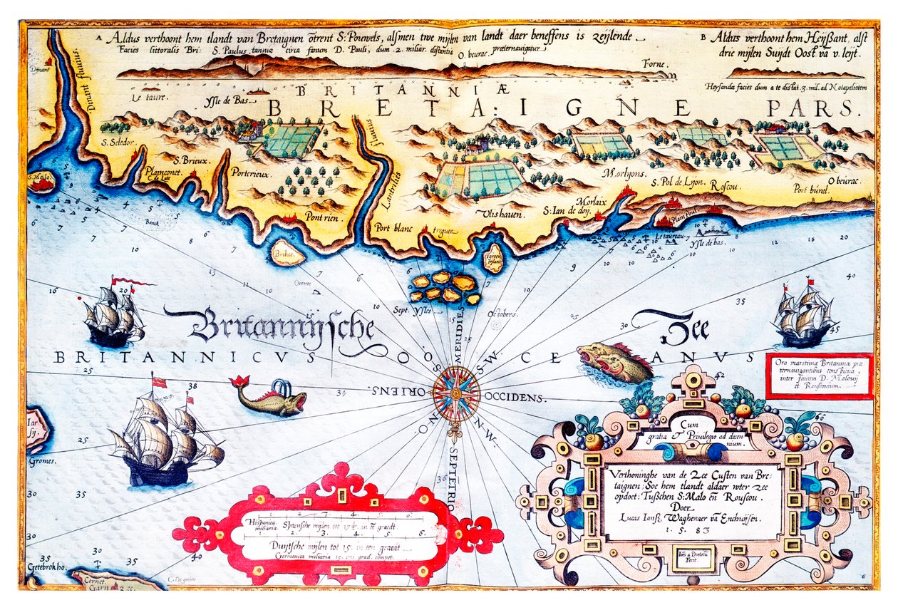
Navigation Chart of Brittany Coast by Lucas Janszoon Waghenaer

Navigation Chart of Brittany Coast

(Navigation chart of Brittany coast)


Lucas Janszoon Waghenaer

€ 0.00
Enthält ??% MwSt.
   Add to cart
   Configure art print
Undated  ·  Picture ID: 1407534

Nonclassified artists

Navigation Chart of Brittany Coast by Lucas Janszoon Waghenaer. Available as an art print on canvas, photo paper, watercolor board, uncoated paper or Japanese paper.
16th century · 16 century · xvi century · xvith century · sixteenth century · c16th · 16 16th xvi xvith century · sec xvi · late 16th century · early 16th century · boat · boats · tugboat · transport · tranport · transportation · passenger transportation · means of transport · mode of transport · france · french · france french · french overseas departments and territories · french culture · coast · coastline · shoreline · coastal · coast scene · coastl · coast scenery · coastal feature · maritime · navy · naval · naval school · army · troops · armed forces · combat unit · platoon · fish · fishes · animal · animals · wildlife animals · wildlife · wild life · several animals · chart · cartography · 16th century · xvi century · brittany · breton · france · french · water · ships · compass · maritime · nautical · dutch · netherlands · sea monster · sea creature · ship · navigation · geography · colourful · bright · bold · vivid · / Bridgeman Images
zu Favoriten hinzufügen   Add to favorites    Select wall color    View painting in a room AR/3D   View in 3D / AR
0 Reviews

Configure art print

Picture Frame

Medium & Stretcher

Glass & Passepartout

Miscellaneous & Extras

 Save / compare configuration
Preview Icon

Summary

Gemälde
Veredelung
Keilrahmen
Museumslizenz

€ 124.8
(inkl. 20% MwSt)
   Add to cart

Bildschärfe: PERFEKT

Should you desire adjustments to brightness and color, or a custom crop of the motif, we are happy to make these changes at no additional cost to you. Please do not hesitate to contact us.

Similar artworks selected for you

Map of the English Coast between the Isle of Wight and Dover Map of the English Coast Between the Isle of Wight and Dover Dutch Trade Map of the Baltic Sea Oversize Atlas Titled Cape Sagres (or Sacred Cape) at the end of Portugal after the portulan of Luca J. Waghenaer Treesor of zeevaert printed in Leiden in 1592 Map of the Republic of Genoa Map of Livonia Die custe va Lijfflandt met de eijlanden daer beneffens Map of Livonia Chart of the English Channel Map of Netherlands, from Theatrum Orbis Terrarum by Abraham Ortelius Map of West African coastline, 1596 Portland Bill to Portsmouth: The Pursuit of the Spanish Armada by the English Fleet Coast of Prussia with all the havens and rivers from Memel to Heel Theatrum Orbis Terrarum Map of the North Coast of England near Newcastle upon Tyne Map of the Coast of Flanders, Normandy and England Map of the North Coast of England Near Newcastle upon Tyne Map of Central America and Peru Illustration from the Map, illustration from the Map of the China Sea, from a Facsimile of the Hollandiae Antiquorum Catthorum Sedis Nova Descriptio, Auctore Lacobo a Daventria. Geography Map of the Territory of the Netherlands with the Cities of Amsterdam and Haarlem... Taken from A map of Africa, south of the equator, with part of the Indian Ocean, from Bristol Channel Map of the newly discovered Nova Zembla, illustration from Diarium Nauticum, seu vera descriptio trium navigationum admirandarum... by Gerrit de Veer Straits of Magellan (engraving) Map of Colombia and Peru. 1590. The Sea Coasts of England Between the Isle of Wight and Dover, with the Principal Havens Thereof According to Their Situation and Appearing Map of the Coasts of Flanders, Normandy, and England
Show more similar artworks

Other art prints by Lucas Janszoon Waghenaer

Map of Livonia Chart of the Coast of England with the Sea Decorated with Ships and Monster Map of Northern Norway with Enlarged Sections of Vardø and Kildin by Willem Barents Map of Livonia Die custe va Lijfflandt met de eijlanden daer beneffens Oversize Atlas Titled The south coast of England Navigation Chart of Brittany Coast Chart of the English Channel Valloton Coast of Prussia with all the havens and rivers from Memel to Heel A Description of the Sea Coasts, of the Land of Algarve, and a Part of the County with Their Show & Opening, c.1588 The Sea Coasts Between Dover & Orfordness: Including the Most Famous River of Thames with All the Sands, Banks, Flats, & Shoals Thereabouts According to Their True Situation and Appearance The Sea Coasts of England Between the Isle of Wight and Dover, with the Principal Havens Thereof According to Their Situation and Appearing Description of the Sea Coasts of Eyder Ditmers and Part of Jeverland East Friesland 1584 Map
Discover more works by Lucas Janszoon Waghenaer

Excerpt from our top sellers

Vase of Flowers Praying Hands Fish Blood Little Oak Tree The Isle of the Dead The Luncheon: Monet Narcissus Resting, 1930 The Mountain Mowers, First Version The Beach at Saint-Clair The Resurrection of Christ (detail) Circe Offering the Cup to Ulysses, 1891 Cliff Walk at Pourville Watercolor No. 326 Cubist Lilies
Show More Artworks


What our customers think about us


Frequently Asked Questions about Meisterdrucke


Personalizing your art print at Meisterdrucke is a simple and intuitive process that allows you to design an artwork exactly to your specifications: Choose a frame, determine the image size, decide on a printing medium, and add suitable glazing or a stretcher frame. We also offer customization options such as mats, fillets, and spacers. Our customer service is available to help you design your perfect artwork.

At Meisterdrucke, you have the fascinating option to visualize the artwork you configured directly in your own space. For a tailored preview, simply upload a photo of your room and let the artwork appear on it. If you visit us via a mobile device, be it a phone or tablet, our augmented reality feature brings the image to life and seamlessly projects it into your space. An experience that uniquely combines art and technology.

Choosing the medium is often a matter of personal taste. To give you a clearer idea, we have provided some images for each medium. For a holistic experience, we also offer you a sample set of all paper variants so you can make a decision not just visually but also haptically. You can take advantage of the sample set free of charge – only the shipping costs will apply. You can order the sample set directly.

Do not worry. At Meisterdrucke, we do not proceed mechanically. We manually review each order. If there are any inconsistencies or peculiarities in the configuration, we will immediately contact you. Of course, our courteous and patient support is always at your side to assist you with the configuration. Together with you, we adjust your image by phone or email so that the final result exactly meets your expectations.


Do you have any questions?

Are you interested in an art print from our manufactory but still unsure? Do you need advice on choosing the medium or help with the order?

Our experts are happy to assist you.

+43 4257 29415
support@meisterdrucke.com
Mo-Do: 7:00 - 16:00 | Fr: 7:00 - 13:00

Do you have any questions?

Are you interested in an art print from our manufactory but still unsure? Do you need advice on choosing the medium or help with the order?

Our experts are happy to assist you.

+43 4257 29415
support@meisterdrucke.com
Mo-Do: 7:00 - 16:00 | Fr: 7:00 - 13:00


Meisterdrucke

   Kärntner Strasse 46
        9586 Finkenstein am Faaker See
        Austria
        +43 4257 29415
        support@meisterdrucke.com
Other languages

                   
Erfahrungen & Bewertungen zu Meisterdrucke
Partner Logos

Kaiser Franz Joseph

Meisterdrucke
Kärntner Strasse 46
9586 Finkenstein am Faaker See · Austria
+43 4257 29415 · office@meisterdrucke.com
Partner Logos


(c) 2025 meisterdrucke.uk